


Together with the nearby river port of Ostia, the area of the Port (Portus) was the maritime port of imperial Rome, which, in constant urban and demographic growth, needed continuous supplies of foodstuffs and various commodities.
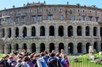
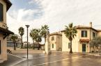
Strolling among the precious historical testimonies and unspoilt nature surrounding the archaeological area of the imperial ports of Claudius and Trajan is like travelling back in time to a place full of reminiscences of the past and suggestions: the ideal place for those who love tranquillity and an unusual but fascinating itinerary, far from the typical tourist destinations and city chaos.
The Port of Claudius
In 42 A.D., Emperor Claudius began the construction of a large seaport north of the mouth of the Tiber, given the progressive silting up of the river port of Ostia.
The new harbour, a vast basin of about 150 hectares with two curved piers and some docking quays, was dominated by a large multi-storey lighthouse, which probably stood on an artificial island that acted as a watershed between the northern and southern approaches to the harbour, dividing it into two mouths.
The port of Claudius was, therefore, a grandiose structure that guaranteed the supply of the Urbe, ensuring the safe transport of goods from large ships designed for navigation on the open sea to river boats (naves caudicariae) built to sail up the Tiber to Rome.
The connection between the port of Claudius and the Tiber was provided by at least two artificial canals, the impressiveness of which can be traced in the foundations of the northern quay, still visible today for a length of about one kilometre behind the Museo delle Navi (Fiumicino Roman Ships Museum).
A number of structures pertaining to the port, such as the 'Capitaneria', a cistern and some thermal buildings (the Monte Giulio complex), dating back to the 2nd century A.D., can also be discerned on the ancient northern quay.
The port was rendered less and less functional and safe by progressive silting up. For this reason, a new dock was built between 100 and 112 AD: the Port of Trajan.
The Port of Trajan
To the lighthouse and quays of the port of Claudius, integrated into the new harbour system, Trajan added a hexagonal basin of 33 hectares, a grandiose engineering work that increased the docking places for ships. Other canals were also dug - including the Fossa Traiana, today's Fiumicino Canal - to allow floods to flow into the sea, freeing Rome from the scourge of inundation.
Among the most important constructions that arose within the harbour were the Magazzini Severiani (Severian Warehouses), large goods storage structures built in the mid-2nd century AD, and the Palazzo Imperiale (Imperial Palace), a sumptuous representative building that hosted high-ranking travellers, both overlooking the hexagonal basin. The Magazzini Traianei (Trajan's Warehouses), on the other hand, developed around the Darsena (Dock), the inner basin where goods were loaded onto small ships sailing up the Tiber and where ships were anchored during the winter months.
The large rusticated columns that you can still admire during your visit are the famous travertine 'colonnacce', the remains of a grandiose portico from the age of Claudius that Trajan reused by closing the spaces between them to create warehouses and offices.
In the 2nd and 3rd centuries, the importance of the port led to the birth of a stable settlement, which officially became a city in 314 A.D. with the name Portus Romae. However, over the centuries, due to the advancing coastline and the changing morphology of the land, it slowly became marshy. The harbour basin was almost completely filled in between the Middle Ages and modern times.
Today, the sea lies about four kilometres from the ancient centre, now enclosed by the infrastructure of the Leonardo da Vinci Airport and modern roadways.
The archaeological area is currently divided between the Parco Archeologico di Ostia Antica (Ostia Antica Archaeological Park) and the Sforza-Cesarini family, owner of the basin of Trajan.
Photo: Parco Archeologico di Ostia Antica
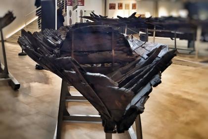
Museo delle Navi - Schiffsmuseum von Fiumicino
 Condividi
Internationaler Flughafen Leonardo da Vinci
 Condividi
Archäologischen Park Ostia Antica
 Condividi
Informationen
From Tuesday to Sunday and on holidays.
From 8.30 - 16.30 (last admission 15.30 ) from 25 October to 28 (or 29) February
From 8.30 - 17.15 (last admission 16.15) from 1st March to 31st March:
From 8.30 - 19.00 (last admission 18.00) from 1st April to 30th September
From 8.30- 18.30 (last admission 18.30) from 1st October to 24th October
Closed on Monday and December 25th.
Special openings: Monday 24 and Tuesday 25 April and Monday 1 May 2023
Special closures: Tuesday 11 April, Wednesday 26 April and Tuesday 2 May 2023
For updates and guidelines consult the official website.
Condividi
Location
Um mehr über alle barrierefreien Dienste zu erfahren, besuchen Sie den Abschnitt barrierefreies Rom.